Roughly 47,000 people visit North Cascades National Park each year. Compare that to the nearly two million who pass through Mount Rainier, just a couple hours south, and you start to understand why this park feels less like a Pacific Northwest weekend trip and more like a corner of interior Alaska that happens to sit within driving distance of Seattle. It holds more glaciers than any other national park in the lower 48 states, jagged peaks earning it the nickname “the American Alps,” and trails that stay genuinely empty even on summer weekends.
Here’s the practical guide for anyone planning a visit: where the park sits, what it costs (nothing, as it turns out), the numbers behind its remarkable glacial density, and the decades-long conservation fight that finally protected it in 1968.
North Cascades National Park Overview
| Category | Details |
| Location | Northern Cascade Range, Washington, near the Canadian border |
| Counties | Whatcom, Skagit, and Chelan |
| Nearest city | Sedro-Woolley, WA |
| Nearest airport | Seattle-Tacoma International (SEA) |
| Established | October 2, 1968 |
| Total area | About 504,700 acres (park alone); ~789,000 acres including the full complex |
| Entrance fee | None — the national park itself has no entrance fee |
| Related fees | Ross Lake and Lake Chelan National Recreation Areas may charge for camping/boat launches |
| Glaciers | Over 300 — the most of any U.S. national park outside Alaska |
| Highest point | Goode Mountain, 9,206–9,220 feet |
| Main access road | State Route 20 (North Cascades Highway), closes mid-November through April |
| Annual visitation | Around 16,000 to 47,000 visitors — one of the least-visited parks in the lower 48 |
Where North Cascades National Park Is Located
North Cascades National Park sits in northern Washington state, close to the Canadian border, spanning Whatcom, Skagit, and Chelan counties. Sedro-Woolley serves as the nearest town with services, while Seattle-Tacoma International Airport offers the most practical air access, with roughly a two to three hour drive to reach the park depending on which entrance you’re using.
The park itself is actually the largest of three units making up the North Cascades National Park Service Complex, alongside the adjacent Ross Lake National Recreation Area and Lake Chelan National Recreation Area, all created together in 1968 and managed as one combined operation. Most developed facilities, campgrounds, and boat access points actually sit within the recreation areas rather than the national park itself, an arrangement that let existing hydroelectric dams and recreational lake use continue while still fully protecting the surrounding wilderness.
State Route 20, known as the North Cascades Highway, is the only paved road running through the park, climbing to 5,477 feet at Washington Pass. It closes seasonally, typically from mid-November through April, due to heavy snowfall, cutting off the most direct route through the park for roughly half the year.
What It Costs to Visit
North Cascades National Park charges no entrance fee at all. You can drive the highway, hike the trails, and explore the wilderness entirely free of charge, a detail that surprises visitors used to paying admission at more heavily marketed parks nearby.
The adjacent Ross Lake and Lake Chelan National Recreation Areas, while managed as part of the same complex, may charge separately for specific activities like camping or boat launches, since recreation areas often operate under slightly different fee structures than the national park core. Because the park itself has no entrance fee, America the Beautiful passes have no direct application here, though they remain useful for other fee-charging parks you might visit on the same Pacific Northwest trip.
Facts That Make North Cascades Extraordinary
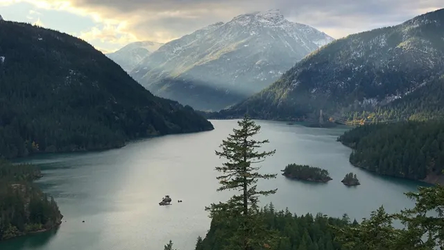
North Cascades holds more than 300 glaciers within its boundaries, more than any other national park in the contiguous United States, a concentration so dense it’s more heavily glaciated than anywhere else in the country outside Alaska. That glacial density directly shapes the park’s scenery: the Skagit River runs milky blue and Diablo Lake glows an almost improbable turquoise-green, both colors caused by finely ground “rock flour” suspended in glacial meltwater.
Elevation swings dramatically here too, from around 400 to 605 feet at the lowest points up to over 9,200 feet at Goode Mountain, the park’s highest peak. That vertical relief supports remarkable biodiversity, with more than 1,600 documented plant species spanning temperate rainforest in western valleys through subalpine meadows and jagged alpine terrain higher up.
Unfortunately, the park’s glaciers are shrinking rapidly. Researchers have documented accelerating retreat throughout the complex in recent decades, with some individual glaciers losing more than half their total area since the 1950s, making North Cascades an active site for ongoing climate research alongside its recreational appeal.
The History Behind North Cascades National Park
Indigenous peoples, including the Upper Skagit, Nlaka’pamux, and Chelan, used this mountainous terrain for thousands of years before European settlement, following seasonal routes through the peaks for hunting, fishing, and trade.
Formal protection efforts date back remarkably far. In 1906, artist Julian Itter, who had gained recognition after painting the region’s scenery for the 1904 St. Louis World’s Fair, worked with outdoor groups and commercial clubs across Washington to push for protecting roughly 300 square miles above the northern end of Lake Chelan as a national park. That early effort failed, largely because residents in nearby towns sided with mining interests over conservation, prioritizing local economic concerns over tourism potential.
The push resumed in earnest decades later. In 1963, Interior Secretary Stewart Udall recommended federal action, and the North Cascades Conservation Council, founded in 1957, led a sustained final campaign for protection. That advocacy succeeded on October 2, 1968, when President Lyndon B. Johnson signed the North Cascades National Park Act, designating roughly 504,000 acres as the core national park while simultaneously creating the adjacent Ross Lake and Lake Chelan National Recreation Areas as part of a broader complex, a compromise that balanced strict wilderness protection with continued recreational use of the major lakes and existing hydroelectric infrastructure. Subsequent additions expanded protected wilderness within the complex, including the designation of the Stephen Mather Wilderness, covering over 634,000 acres of the park’s most remote terrain.
Frequently Asked Questions
Q1. Why does North Cascades get so few visitors compared to nearby parks like Mount Rainier?
It’s largely a matter of visibility and marketing rather than accessibility; the park sits within a comparable drive from Seattle but historically hasn’t drawn the same attention. That relative obscurity is actually a major draw for visitors seeking uncrowded trails and genuine solitude.
Q2. Is State Route 20 open year-round, or should I plan around seasonal closures?
No, it closes seasonally, typically from mid-November through April due to heavy mountain snowfall. Check current road status before planning a trip, since exact opening and closing dates shift year to year based on snowpack.
Q3. If the national park has no entrance fee, do I need to pay anything at all to visit?
Not for the park itself, but activities within the adjacent Ross Lake and Lake Chelan National Recreation Areas, like camping or boat launches, may carry separate fees. Check specific facility pages before your trip if you’re planning to camp or use lake access points.
Q4. Why do Diablo Lake and the Skagit River have such an unusual color?
Both get their striking blue-green and turquoise hues from glacial rock flour, extremely fine sediment ground up by the park’s glaciers and suspended in the water. It’s a direct visual result of the park holding more glaciers than any other national park outside Alaska.