There’s no scenic drive looping through Voyageurs National Park, and that’s not an oversight; it’s the entire point. About 40% of this park is water, a maze of interconnected lakes and forested islands along Minnesota’s border with Canada, and the only way to actually see most of it is by boat. Named for the French-Canadian fur traders who once paddled these same waterways in massive birchbark canoes, Voyageurs remains Minnesota’s only national park and one of the very few in the country where you’re genuinely encouraged to leave your car behind entirely.
Here’s the practical guide for anyone planning a visit: where the park sits, what it costs (free to enter, though houseboats and camping aren’t), the numbers behind its unusual water-based layout, and the nearly century-long path from a state legislature’s first proposal to actual federal protection.
Voyageurs National Park Overview
| Category | Details |
| Location | Northern Minnesota, on the border with Ontario, Canada |
| Counties | St. Louis and Koochiching |
| Nearest city | International Falls, MN |
| Nearest airport | Falls International Airport (INL) |
| Established | Authorized 1971; established April 8, 1975 |
| Total area | About 218,200 acres, roughly 40% water |
| Entrance fee | None — free to visit year-round |
| Camping fee | Applies at reservable island campsites |
| Houseboat NPS permit | $15 per night, plus a $10 Recreation.gov reservation fee |
| Major lakes | Rainy, Kabetogama, Namakan, and Sand Point |
| Interior land mass | Kabetogama Peninsula, accessible only by boat, snowmobile, ski, or snowshoe |
| Annual visitation | Around 200,000 to 240,000 visitors |
Where Voyageurs National Park Is Located
Voyageurs National Park sits in the far northern reaches of Minnesota, directly along the Canadian border, near the town of International Falls, sometimes called the coldest city in the country and a genuine gateway feel for a park this remote. Falls International Airport offers the closest air access, though the drive itself, once you’re in the region, remains straightforward along established highways leading to the park’s four visitor centers.
Those visitor centers, Rainy Lake, Kabetogama Lake, Ash River, and Crane Lake, sit on the park’s periphery, each providing boat access to the water-bound interior. Rainy Lake operates year-round, while the others follow seasonal schedules, generally open from mid-to-late May through late September. The Kabetogama Peninsula, which forms the bulk of the park’s interior landmass, has no road access whatsoever; reaching it requires a boat in summer or travel over frozen lakes by snowmobile, ski, or snowshoe once winter sets in.
What It Costs to Visit
Voyageurs National Park charges no entrance fee at all, a genuine rarity among the country’s most prominent Midwest parks. You can drive to any of the four visitor centers and explore the shoreline entirely free.
What isn’t free is actually getting out onto the water and staying overnight, which is how most visitors experience the park’s best features. Houseboats, the park’s signature experience, are operated by concessionaires based outside the park boundaries and require a separate $15 per-night National Park Service permit plus a $10 Recreation.gov reservation fee. Island campsites throughout the park are also reservable and carry their own camping fees, and ranger-led boat tours to popular spots like Kettle Falls Hotel or the Ellsworth Rock Gardens are booked in advance through Recreation.gov as well.
Because there’s no entrance fee here, America the Beautiful passes have no direct application at Voyageurs, though they remain useful for other national parks on a broader Midwest or cross-country itinerary.
Facts That Make Voyageurs Uniquely Water-Bound
Roughly 40% of the park’s total acreage is water, spread across four major lakes, Rainy, Kabetogama, Namakan, and Sand Point, along with more than two dozen smaller interior lakes scattered throughout the Kabetogama Peninsula. Unlike the neighboring Boundary Waters Canoe Area Wilderness, Voyageurs permits motorized watercraft, making it accessible to visitors who prefer motorboats and houseboats over paddling alone.
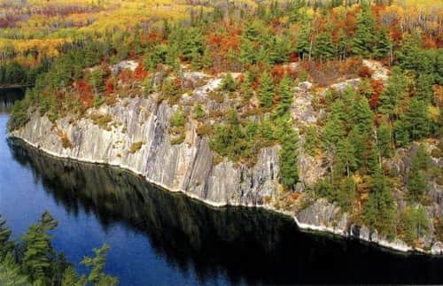
The landscape here was shaped directly by the retreat of glacial Lake Agassiz at the end of the last ice age, an ancient body of water that once covered parts of Minnesota, the Dakotas, and central Canada, leaving behind the smooth, rounded pink and gray bedrock outcrops visible along the park’s shorelines and islands today. Wildlife here reflects the boreal forest setting, with wolves, moose, black bears, and eagles all present, and the region’s minimal light pollution makes the northern lights a regular, genuine sight for overnight visitors.
Fishing ranks among the park’s primary draws, with walleye, northern pike, lake trout, and muskellunge all commonly targeted, though anglers need a valid Minnesota state fishing license regardless of the park’s own fee-free status.
The History Behind Voyageurs National Park
People first arrived in this region roughly 10,000 years ago, as the waters of glacial Lake Agassiz receded and left behind the chain of lakes that still defines the landscape today. Centuries later, French-Canadian fur traders known as voyageurs paddled these same interconnected waterways during the 17th and 18th centuries, transporting furs in massive birchbark canoes along routes that gave the park its name.
The 19th and early 20th centuries brought brief periods of resource extraction to the area. A small gold rush erupted in 1893 after gold-bearing quartz was discovered on Little American Island, sparking the short-lived boomtown of Rainy Lake City before the deposits proved insufficient to sustain long-term mining. Intensive logging followed soon after, with lumber companies rafting massive white pine logs across the lakes to Hoist Bay until operations wound down in the late 1930s.
Formal protection efforts date back remarkably far. The Minnesota Legislature first proposed a national park here in a resolution passed in April 1891, nearly 80 years before federal action actually followed. Sustained advocacy from local conservationists eventually paid off when President Richard Nixon signed authorizing legislation on January 8, 1971, and Voyageurs officially opened as Minnesota’s only national park on April 8, 1975, formally protecting a landscape that had been proposed for federal protection since the late 19th century.
Frequently Asked Questions
Q1. If the park has no entrance fee, what should I actually budget for a visit?
Budget for a houseboat rental or campsite reservation if staying overnight, since those carry separate fees, plus any guided boat tours through Recreation.gov. A single-day visit to a visitor center and nearby shoreline trails can genuinely cost nothing beyond gas and food.
Q2. Do I need my own boat, or can I rent one locally?
Local outfitters near each of the four visitor centers rent motorboats, canoes, kayaks, and houseboats, so bringing your own boat isn’t necessary. Water taxis are also available at Rainy Lake and Kabetogama to drop hikers at trailheads on the Kabetogama Peninsula.
Q3. Is it possible to hike anywhere in the park without a boat?
Most named hiking trails, including the popular Cruiser Lake Trail, sit on the Kabetogama Peninsula, which has no road access at all. Reaching those trailheads requires a boat ride in, typically arranged through a water taxi or your own watercraft.
Q4. When is the best time to see the northern lights at Voyageurs?
Fall and winter generally offer the longest nights and clearest skies for aurora viewing, combined with the park’s minimal light pollution. Check current aurora forecasts before your trip, since visibility still depends heavily on solar activity regardless of season.