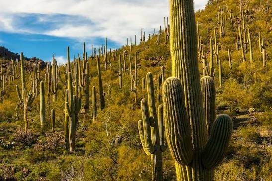
A saguaro cactus doesn’t grow its first arm until roughly age 75, and it can take a century or more before one starts to look like the towering, many-armed silhouette everyone pictures when they think of the American Southwest. These plants live 150 to 200 years, grow only an inch or two in their first decade, and can weigh over eight tons once fully swollen with water. Saguaro National Park exists specifically to protect roughly 2 million of them, split across two mountain ranges on opposite sides of Tucson, Arizona.
Here’s the practical guide for planning a visit: where the park sits, what it costs, the numbers behind this remarkably slow-growing cactus, and the decades of advocacy it took to protect these plants from grazing cattle, thieves, and encroaching development.
Saguaro National Park Overview
| Category | Details |
| Location | Sonoran Desert, southeastern Arizona, split around Tucson |
| Districts | Tucson Mountain District (West) and Rincon Mountain District (East) |
| Nearest city | Tucson, AZ |
| Nearest airport | Tucson International (TUS) |
| Established | March 1, 1933 (national monument); October 14, 1994 (national park) |
| Total area | About 92,000 acres combined |
| Vehicle entrance fee | $25, valid 7 consecutive days (covers both districts) |
| Motorcycle fee | $20 |
| Per-person fee (foot/bicycle) | $15 |
| America the Beautiful Annual Pass | $80 (all U.S. national parks) |
| Payment method | Cashless — credit/debit card only |
| Distance between districts | About 30 miles, roughly an hour’s drive |
| Highest point | Mica Mountain, 8,666 feet |
| Saguaro cactus lifespan | 150–200 years |
| Annual visitation | Around 950,000 to 1 million visitors |
Where Saguaro National Park Is Located
Saguaro National Park sits on two sides of Tucson, Arizona, separated by the city itself and roughly 30 miles apart by road. The Tucson Mountain District, often called Saguaro West, lies about 10 miles west of downtown, while the Rincon Mountain District, or Saguaro East, sits roughly 10 miles east and is significantly larger, rising to higher elevations in the Rincon Mountains.
Tucson International Airport is the natural arrival point for most visitors, sitting roughly 25 to 30 minutes from either district. Because the two sides aren’t connected by any road within the park, visitors typically pick one district to focus on for the day rather than trying to cover both, especially given the hour-long drive between them through the city.
Each district offers a genuinely different experience: the West side sits at lower elevation with dense saguaro forests close to the visitor center, while the East side’s higher terrain in the Rincon Mountains introduces oak and pine forest zones well above the desert floor, meaning a single hike there can move through multiple distinct ecosystems.
What It Costs to Visit
A standard vehicle pass costs $25 and covers both districts for seven consecutive days, a detail worth knowing if you’re planning to visit both sides during an extended Tucson trip. Motorcycles pay $20, and visitors on foot or bicycle pay $15 per person.
Anyone planning trips to multiple national parks during the year typically prefers the $80 America the Beautiful Pass, which covers admission to every federal recreation site nationwide. Entrance stations here are cashless, requiring a credit or debit card at either the Red Hills Visitor Center on the west side or the fee kiosk and visitor center on the east side.
One practical detail worth planning around: neither district has concessions, restaurants, or snack machines, part of the park’s reduce-reuse-refill approach, so bringing your own food and water is essential. Water fountains exist only at the two visitor centers, nowhere else in the park.
Facts That Make Saguaro Unique
The saguaro cactus is astonishingly slow-growing, gaining only about one to two inches during its first eight years of life and typically not sprouting its first arm until around age 75. Fully mature specimens can reach over 50 feet tall and weigh more than eight tons when saturated with water after seasonal rains, with one documented individual growing as many as 78 arms.
The park’s two districts sit atop genuinely different geology: the Tucson Mountains to the west are volcanic in origin, while the Rincon Mountains to the east are metamorphic, giving the park a more complex geological history than its cactus-forest reputation might suggest. Elevation swings dramatically in the Rincon Mountain District, climbing to 8,666 feet at Mica Mountain, high enough to support ponderosa pine, oak, and Douglas fir forest zones far removed from the desert scrub found lower down.
Beyond its namesake cactus, the park hosts more than 1,160 documented plant species and supports wildlife ranging from desert-adapted snakes and owls to black bears and mule deer in the higher elevations of the Rincon Mountains.
The History Behind Saguaro National Park
Concerns about the saguaro cactus’s future date back to the late 1920s, when University of Arizona President Homer Shantz arranged the purchase of 480 acres of saguaro habitat specifically to preserve it as an outdoor scientific laboratory, envisioning a protected area spanning desert and mountain terrain that future generations of researchers could study undisturbed.
Local advocate Frank Hitchcock, publisher of the Arizona Citizen at the time, took Shantz’s vision to President Herbert Hoover, who agreed and issued a proclamation on March 1, 1933, establishing Saguaro National Monument in the Rincon Mountains. Protection didn’t immediately end the threats facing the cacti; cattle grazing continued to trample young seedlings, and cactus thieves stole specimens for illegal transplanting elsewhere, concerns that advocates kept pressing for decades afterward.
Momentum for expansion built through the mid-20th century, and on November 15, 1961, President John F. Kennedy added the Tucson Mountain District to the monument, incorporating land that had previously been part of Pima County’s Tucson Mountain Park since local conservationists secured its protection from mining and homesteading back in 1929. That western section carries its own industrial history too, having once held 137 separate mining sites extracting copper, lead, silver, and molybdenum from the mid-1800s through the early 1900s.
Full national park status arrived on October 14, 1994, when Congress elevated the combined monument to Saguaro National Park, shortly before two other Southwestern desert parks, Joshua Tree and Death Valley, received the same designation that same year.
Frequently Asked Questions
Q1. Can I visit both districts in a single day?
It’s possible but ambitious, since the drive between them takes about an hour through Tucson traffic. Most visitors get a fuller experience by dedicating a half or full day to just one district rather than rushing between both.
Q2. Is overnight camping available anywhere in the park?
Only in the Rincon Mountain District (East), and only as hike-in backcountry wilderness camping with no vehicle access, showers, or running water. The Tucson Mountain District (West) doesn’t offer any overnight camping at all.
Q3. What’s the best time of year to see saguaros blooming?
Saguaro flowers typically bloom at night in May and June, with fruit ripening shortly after in June. Spring wildflower displays across the desert floor usually peak from late February through early April, depending on winter rainfall.
Q4. Should I be worried about cell service or getting lost on trails?
Cell service is genuinely unreliable throughout both districts. Download offline maps or grab a paper map at a visitor center before heading out, since Wi-Fi is only available at the two visitor centers and nowhere else in the park.