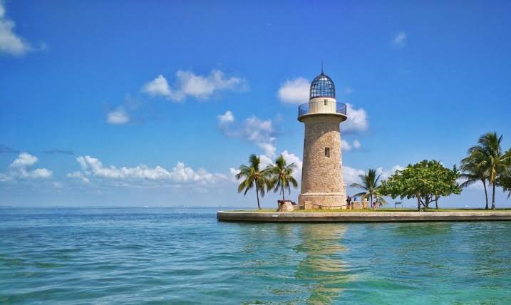
Standing at the visitor center, you can see almost none of Biscayne National Park. That’s not an exaggeration: 95% of its roughly 173,000 acres sits underwater, making it one of the most unusual national parks in the entire system, a place defined by coral reef, mangrove shoreline, and open bay rather than hiking trails and mountain overlooks. Reaching most of it requires a boat, and reaching the park at all required winning a fierce battle against oil refineries and a planned Miami Beach-style resort development.
Here’s the practical guide for anyone planning a visit: where the park sits, what it costs (nothing to enter, though boat tours aren’t free), the numbers behind its mostly submerged geography, and the development fight that nearly turned this stretch of Biscayne Bay into an industrial seaport.
Biscayne National Park Overview
| Category | Details |
| Location | Miami-Dade County, Florida, about 20 miles south of Miami |
| Nearest city | Homestead, FL |
| Nearest airport | Miami International Airport (MIA), about 35 miles away |
| Established | Biscayne National Monument on October 18, 1968; national park on June 28, 1980 |
| Total area | About 172,970 acres — roughly 95% underwater |
| Entrance fee | None — free to enter |
| Boat tours | Paid, booked through concessionaires like the Biscayne National Park Institute |
| Land area | Only about 9,075 acres |
| Largest island | Elliott Key — the northernmost of the “true” Florida Keys |
| Coral reef system | Part of the Florida Reef, the world’s third-largest barrier reef |
| Best time to visit | December through April |
Where Biscayne National Park Is Located
Biscayne National Park sits in Miami-Dade County, about 20 miles south of downtown Miami, occupying the northern end of the Florida Keys between Key Biscayne and Key Largo. The main access point is the Dante Fascell Visitor Center at Convoy Point in Homestead, reachable by car and offering the only significant land-based facility in the entire park.
Miami International Airport, roughly 35 miles north, is the natural arrival point for most visitors, with car rental necessary since there’s no public transportation directly to the park. Beyond the visitor center area and a jetty at Black Point Marina, virtually the entire park, its islands, reefs, and open water, is accessible only by boat, whether through a guided tour or a private vessel.
What It Costs to Visit
Biscayne National Park charges no entrance fee at all. Anyone can drive to the visitor center, walk the shoreline trails, and explore the Convoy Point area completely free.
What isn’t free is actually experiencing most of what makes the park special, since reaching the reefs, islands, and open bay water requires a boat. Guided boat tours, snorkeling trips, and glass-bottom boat excursions are offered through park concessionaires, most notably the Biscayne National Park Institute, and these come at their own separate cost, booked in advance since popular tours can sell out during peak season. Visitors with their own boats can explore independently, though speaking with a park ranger beforehand about navigation and current conditions is a smart move given how much of the park is water-based backcountry.
Because there’s no entrance fee here, America the Beautiful passes have no direct function at Biscayne, though they remain useful for other national parks on the same Florida itinerary.
Facts That Make Biscayne Unique
Of the park’s roughly 173,000 total acres, only about 9,075 sit on dry land, meaning the overwhelming majority of Biscayne exists beneath the surface of Biscayne Bay, the Atlantic Ocean, and the channels running through the northern Florida Keys. That underwater majority protects part of the Florida Reef, the third-largest barrier reef system in the world, supporting more than 500 fish species alongside jellyfish, sea turtles, and manatees.
Elliott Key, the park’s largest island, holds the distinction of being the northernmost of the “true” Florida Keys, islands formed from fossilized coral rather than the sand-based islands more commonly associated with tropical coastlines. The mangrove shoreline near the visitor center forms the longest continuous stretch of mangrove forest anywhere on the eastern coast of the United States, a critical nursery habitat for the marine life that draws snorkelers and divers to the park.
Beneath the water, Biscayne also preserves a genuinely significant piece of maritime history: six documented historic shipwrecks lie within park boundaries, remnants of centuries of vessels that met trouble navigating the shallow reefs and channels of this stretch of coast.
The History Behind Biscayne National Park
Biscayne Bay remained largely undeveloped until the 1960s, when a wave of proposals threatened to transform the area dramatically, including plans to develop the surrounding keys in the style of Miami Beach and to construct a deepwater seaport supporting oil refineries and petrochemical facilities along the mainland shore. Two fossil-fueled power plants and two nuclear power plants were actually built along the bay’s shores during this period, underscoring how close the area came to full industrialization.
Opposition to further development grew quickly among local citizens, scientists, and conservationists alarmed at the pace of change. The fight got genuinely contentious: pro-development interests bulldozed a path as wide as a six-lane highway and roughly 7 miles long down Elliott Key, an attempt to physically damage the island’s vegetation and undermine the case for protecting it. Despite that effort, conservation advocates prevailed, and on October 18, 1968, President Lyndon B. Johnson signed legislation establishing Biscayne National Monument, protecting the bay and its ecosystems from further industrial encroachment.
The monument’s boundaries expanded in 1974, and on June 28, 1980, Congress elevated the site to full national park status, formally recognizing its combination of terrestrial, marine, and amphibious ecosystems as worthy of the highest level of federal protection. Today, the same bulldozed path once cut to prevent the park’s creation survives as a hiking trail on Elliott Key, a quiet reminder of just how close this stretch of coastline came to a very different future.
Frequently Asked Questions
Q1. Do I need my own boat to see anything worthwhile at Biscayne, or can I book a tour?
You don’t need your own boat. Guided boat tours, snorkeling excursions, and glass-bottom boat trips are available through concessionaires like the Biscayne National Park Institute, making the park’s reefs and islands accessible without owning or renting a private vessel.
Q2. Is camping available anywhere in the park, and how do I get to a campsite?
Yes, but only at designated island campgrounds on Elliott Key and Boca Chita Key, both reachable exclusively by boat. There’s no drive-in camping option, since virtually the entire park beyond the visitor center requires water access.
Q3. What’s the best time of year to visit for calm water and good visibility?
December through April generally offers the calmest conditions and best water clarity for snorkeling and diving, while summer brings higher humidity, more frequent storms, and choppier water that can limit boat tour visibility.
Q4. Can I see coral reefs without getting in the water myself?
Yes, glass-bottom boat tours let visitors view the reef and marine life without swimming or snorkeling, making the park’s underwater scenery accessible to those who prefer to stay dry or aren’t comfortable in open water.