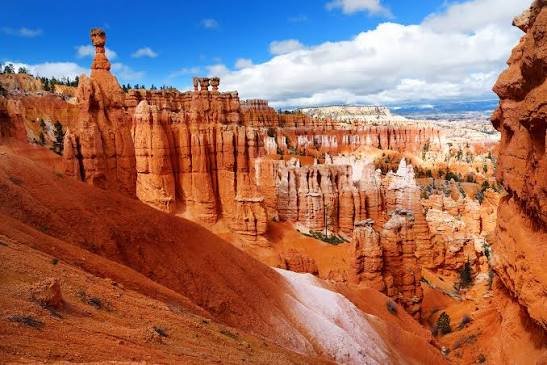
Bryce Canyon isn’t actually a canyon. It’s a series of natural amphitheaters carved into the eastern edge of a plateau, filled with thousands of thin, colorful rock spires called hoodoos, the largest concentration of these formations found anywhere on Earth. The Paiute people who lived in this region long before European settlement told stories of “Legend People” turned to stone here as punishment for their misdeeds, a fitting myth for a landscape that looks, at certain hours of the day, genuinely otherworldly.
Here’s the practical guide for anyone planning a visit: where the park sits, what it costs, the numbers behind its record-setting rock formations, and the story of the frustrated rancher whose name the park still carries today.
Bryce Canyon National Park Overview
| Category | Details |
| Location | Southwestern Utah, Paunsaugunt Plateau |
| Counties | Garfield and Kane |
| Nearest towns | Tropic and Panguitch, UT |
| Nearest airport | Las Vegas Harry Reid International (LAS), about 4 hours away |
| Established | National monument in 1923; national park on February 25, 1928 |
| Total area | About 35,835 acres |
| Vehicle entrance fee | $35, valid 7 consecutive days |
| Motorcycle fee | $30 |
| Per-person fee (foot/bicycle) | $20 |
| America the Beautiful Annual Pass | $80 (all U.S. national parks) |
| International visitor surcharge (2026) | $100 per person, age 16+ (waived with a qualifying annual pass) |
| Elevation range | 6,620 feet (Yellow Creek) to 9,115 feet (Rainbow Point) |
| Bryce Amphitheater size | 12 miles long, 3 miles wide, about 800 feet deep |
| Annual visitation | Around 2.4 to 2.5 million visitors |
Where Bryce Canyon National Park Is Located
Bryce Canyon sits in southwestern Utah along the eastern rim of the Paunsaugunt Plateau, at a notably higher elevation than nearby Zion National Park, with the rim ranging between roughly 8,000 and 9,000 feet. The towns of Tropic and Panguitch serve as the nearest bases for lodging, while Kanab, Utah sits at a central point convenient for anyone combining Bryce with a broader trip that includes Zion or the Grand Canyon.
Las Vegas Harry Reid International Airport offers the most flight options for most visitors, though the drive from there runs roughly four hours, since Bryce sits deep within Utah’s rural southern reaches. Its relatively remote location, compared to Zion or the Grand Canyon, is part of why it historically drew fewer visitors, even though annual numbers have climbed substantially in recent years.
The park itself stretches over 20 miles north to south, following a series of amphitheaters along the plateau’s edge, with the largest, Bryce Amphitheater, measuring roughly 12 miles long, 3 miles wide, and 800 feet deep.
What It Costs to Visit
A standard vehicle pass costs $35, covering everyone inside for seven consecutive days. Motorcycles pay $30, and visitors on foot or bicycle pay $20 per person.
Travelers planning trips to multiple national parks during the year typically prefer the $80 America the Beautiful Pass, which covers admission to every federal recreation site nationwide.
As of January 1, 2026, Bryce Canyon joined ten other high-traffic parks in charging non-U.S. residents an additional $100 surcharge per person, on top of the standard entrance fee. A $250 non-resident annual pass waives that surcharge and covers the pass holder plus everyone traveling in the same vehicle, making it a strong value for anyone visiting Bryce alongside Zion or the Grand Canyon on the same Utah-Arizona itinerary, since all three now charge the same surcharge structure. Entrance stations here are cashless, so a credit or debit card is required.
Facts That Make Bryce Canyon Unique
Bryce Canyon holds the largest concentration of hoodoos anywhere on Earth, with countless thin rock spires, some rising up to 200 feet tall, packed into a series of amphitheaters carved from the colorful limestone, siltstone, and mudstone of the Claron Formation. These formations took shape through frost weathering and stream erosion acting on sediment originally deposited in ancient lakes and streams roughly 63 to 40 million years ago.
Elevation within the park ranges from 6,620 feet at Yellow Creek up to 9,115 feet at Rainbow Point, the endpoint of an 18-mile scenic drive that offers views stretching toward the Aquarius Plateau, Henry Mountains, and Vermilion Cliffs on clear days. That elevation range creates three distinct climate zones within a relatively compact park, spruce and fir forest at the highest elevations, ponderosa pine forest in the middle range, and pinyon pine and juniper woodland lower down.
Thanks to exceptionally clean air and minimal light pollution, Bryce Canyon offers some of the darkest night skies in the country, with over 7,500 stars visible to the naked eye on a clear night, making it a genuine destination for stargazing beyond its daytime scenery.
The History Behind Bryce Canyon National Park
The Paiute people occupied this region starting around 1200 A.D., following earlier but likely non-permanent use by Ancestral Puebloan and Fremont peoples, who were probably deterred by the area’s harsh winters. Paiute oral tradition describes the hoodoos as Legend People, transformed to stone by a trickster figure as punishment for wrongdoing, a story tied directly to the landscape’s strange, humanlike rock formations.
Mormon pioneers settled the surrounding area in the 1850s, and the park’s namesake, Ebenezer Bryce, a Scottish immigrant and carpenter, homesteaded directly below what’s now called Bryce Amphitheater around 1874. Bryce grazed cattle in the terrain and famously described the amphitheaters as “a hell of a place to lose a cow,” a blunt assessment that nonetheless stuck as the area’s informal name among other settlers. Drought and overgrazing eventually pushed most homesteaders, including Bryce himself, out of the area; he relocated his family to Arizona in 1880.
Public interest in the scenery grew after magazine articles published by the Union Pacific and Santa Fe railroads in 1916 and 1918 introduced the area to a wider audience, though poor access and limited lodging kept visitation modest for years. President Warren G. Harding designated the area a national monument in 1923, and after a multi-year process transferring private and state-held land to federal ownership, Congress established Bryce Canyon National Park on February 25, 1928. The park’s boundaries expanded significantly afterward, with President Herbert Hoover more than doubling its size through proclamations in 1931, before a final 1942 addition brought the park to its current 35,835 acres.
Frequently Asked Questions
Q1. Is Bryce Canyon actually a canyon, or is that name misleading?
It’s misleading, technically. Bryce Canyon is a series of natural amphitheaters eroded into the edge of the Paunsaugunt Plateau, not a canyon carved by a single river, though the name has stuck since early settlers first used it informally.
Q2. When is the best time to see the hoodoos without heavy snow or crowds?
Late spring (May) and early fall (September through October) generally offer the best balance of mild weather, manageable crowds, and clear access to the rim trails. Winter brings snow that can be beautiful against the red rock but also limits some road and trail access.
Q3. Do I need a permit for stargazing or astronomy programs?
No permit is required for general stargazing, and the park hosts ranger-led astronomy programs seasonally, though seating or participation can be limited on popular nights. Arriving early for scheduled programs is the best strategy during peak season.
Q4. How does the international surcharge work if I’m visiting Bryce, Zion, and the Grand Canyon on the same trip?
Each park charges its own separate $100 per-person surcharge unless you hold the $250 non-resident annual pass, which covers all three parks (along with every other qualifying park) for the pass holder and vehicle passengers, typically making it the better financial choice for a multi-park Utah-Arizona itinerary.