Drive far enough into West Texas and cell service disappears, towns thin out to nothing, and eventually you reach a park where the Rio Grande carves a hard northeastward turn against a backdrop of desert, canyon, and an entire mountain range rising straight out of the Chihuahuan Desert floor. Big Bend is remote by design and by geography, sitting hundreds of miles from the nearest major city, which is exactly why its night skies rank among the darkest protected anywhere in the country.
If you’re planning a trip to this corner of Texas, here’s what to know: where the park sits, what it costs, the numbers that define it, and how a state park scraped together from Depression-era land purchases eventually became one of the country’s most isolated national parks.
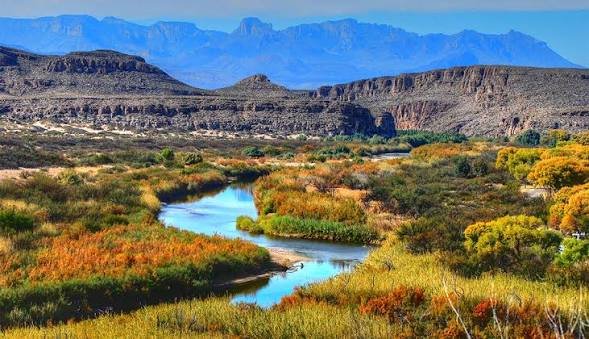
Big Bend National Park Overview
| Category | Details |
| Location | West Texas, along the U.S.-Mexico border |
| County | Brewster County |
| Nearest town | Alpine, TX (roughly 100 miles away) |
| Nearest airport | Midland International Air & Space Port (MAF), about 3.5 hours away |
| Established | Authorized 1935; officially established June 12, 1944 |
| Total area | About 801,000 acres (roughly 1,252 square miles) |
| Vehicle entrance fee | $30, valid 7 consecutive days |
| Motorcycle fee | $25 |
| Per-person fee (foot/bicycle) | $15 |
| Big Bend Annual Pass | $55 |
| America the Beautiful Annual Pass | $80 (all U.S. national parks) |
| Payment method | Cashless — credit or debit card only |
| Rio Grande border stretch | 118 miles along the park’s southern edge |
| Highest peak | Emory Peak, 7,832 feet |
| Lowest point | Rio Grande Village, about 1,850 feet |
| UNESCO status | International Biosphere Reserve since 1976 |
| 2025 visitation | About 568,000 visitors, among the least-crowded major parks |
Where Big Bend National Park Is Located
Big Bend sits in the far southwestern corner of Texas, tucked into Brewster County along a dramatic bend in the Rio Grande where the river forms the border with Mexico. It’s genuinely remote — the closest town of any size, Alpine, sits roughly 100 miles north, and the nearest commercial airport, Midland International, is a solid three-and-a-half-hour drive away.
That isolation shapes everything about visiting. There’s no quick day trip in from a nearby city, and cell coverage disappears almost entirely once you’re inside the park boundary. What you get in return is scenery split across three distinct zones: the Chihuahuan Desert floor, the Chisos Mountains rising abruptly from its center, and the river corridor along the park’s southern edge, complete with steep limestone canyons carved by the Rio Grande over millions of years.
One detail unique to Big Bend: the Boquillas Crossing port of entry lets visitors legally cross into the small Mexican village of Boquillas del Carmen, a rare and low-key international border crossing built right into a U.S. national park. It requires a passport and a modest crossing fee, separate from the park’s standard entrance cost.
What It Costs to Visit
Entry runs $30 for a private vehicle, covering everyone inside for seven consecutive days. Motorcycles pay $25, and visitors arriving on foot or bicycle pay $15 per person.
Frequent visitors typically pick up the $55 Big Bend Annual Pass, while travelers planning trips to multiple national parks during the year usually opt for the $80 America the Beautiful Pass, which covers admission to every federal recreation site nationwide.
Big Bend does not require advance reservations to enter, and there’s no daily visitor cap, unlike some more heavily trafficked western parks. The one firm rule: the park is entirely cashless. All entrance and camping fees must be paid by credit or debit card, either in advance online or at the entrance station itself.
Before planning your route inside the park, it’s worth checking current conditions at the Chisos Basin, since that area has periodically dealt with closures related to infrastructure work in recent seasons, which can affect access to some of the park’s most popular hiking trailheads.
Facts That Make Big Bend Unique
Big Bend protects the largest stretch of Chihuahuan Desert topography anywhere in the United States, a landscape supporting more than 1,200 plant species, over 450 bird species, and dozens of reptile and mammal species, an unusually high count for a single desert park. The Chisos Mountains sit almost entirely within the park’s boundaries, making Big Bend one of the few national parks to contain an entire mountain range rather than just a portion of one.
Elevation swings dramatically across the park, from around 1,850 feet at Rio Grande Village up to 7,832 feet at Emory Peak, creating microclimates that shift from desert scrub to forested mountain terrain within a relatively short drive. That range in elevation also means temperatures can differ by 20 degrees or more between the desert floor and the higher Chisos Basin on the same day.
Big Bend’s remoteness has made it one of the best stargazing destinations in the National Park System, with light pollution levels low enough to see the Milky Way clearly on most clear nights, a rarity increasingly hard to find anywhere in the continental U.S.
The History Behind Big Bend National Park
Protection of this stretch of West Texas began modestly in 1933, when the Texas legislature set aside land around the Santa Elena, Mariscal, and Boquillas canyons to create what was first called Texas Canyons State Park. The name changed to Big Bend State Park later that same year, once the Chisos Mountains were folded into the protected acreage.
The National Park Service investigated the area in 1934 and recommended it for full national park status. Congress passed the authorizing legislation on June 20, 1935, but turning that authorization into an actual national park took nearly a decade, largely because Texas had to acquire the land through public and private donations before transferring it to the federal government. Most of the necessary acreage was finally secured by 1942, and the park was officially dedicated and opened to the public on June 12, 1944.
There was even a grander vision attached to the park’s early history. In 1944, President Franklin Roosevelt worked with Mexican President Manuel Ávila Camacho on a proposal for a binational protected area spanning both sides of the border, an idea that never fully materialized but laid groundwork for later conservation cooperation. Decades afterward, in the 1980s, The Nature Conservancy helped transfer roughly 57,000 acres in the Rosillos Mountains into the park, one of the larger land additions in Big Bend’s history and a reminder that its boundaries have continued evolving well past the original 1944 dedication.
Frequently Asked Questions
Q1. Do I need a reservation to enter Big Bend National Park?
No. Unlike parks such as Yosemite or Rocky Mountain, Big Bend doesn’t require advance entry reservations or issue daily visitor caps, so you can generally plan a trip with more flexibility.
Q2. Can I really cross into Mexico from inside the park?
Yes, through the Boquillas Crossing port of entry, which lets visitors with a valid passport cross into the village of Boquillas del Carmen. It requires a separate crossing fee and passport, distinct from the park’s standard entrance pass.
Q3. What’s the best season to visit given how hot the desert gets?
Late fall through early spring offers the most comfortable temperatures, particularly November through March. Summer desert-floor temperatures regularly exceed 100°F, making the higher-elevation Chisos Basin a cooler alternative if you’re visiting during warmer months.
Q4. Is cell service available anywhere inside the park?
Coverage is extremely limited and unreliable throughout most of Big Bend. Download offline maps and directions before you arrive, and don’t count on being able to make calls or use data once you’re inside the park boundary.