Ask anyone who’s driven the Going-to-the-Sun Road at sunrise, and they’ll tell you the same thing: photos don’t do it justice. Sheer granite walls drop straight into turquoise lakes, mountain goats pick their way across cliff faces that look unclimbable, and somewhere above the treeline, a glacier that’s been shrinking for a century still clings to the rock. Glacier National Park earned the nickname “Crown of the Continent,” and once you’ve seen the Continental Divide split the land in front of you, that name stops sounding like marketing.
If you’re planning a trip to northwest Montana, or just trying to understand why this park keeps landing on every serious hiker’s bucket list, here’s a straightforward rundown of where it is, what it costs, and how it came to be protected in the first place.
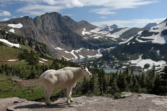
Glacier National Park Overview
| Category | Details |
| Location | Northwest Montana, bordering Alberta and British Columbia, Canada |
| Nearest city | Kalispell, MT (about an hour away) |
| Nearest towns | West Glacier, Columbia Falls, St. Mary |
| Nearest airport | Glacier Park International Airport (FCA), Kalispell |
| Established | May 11, 1910 — the 10th U.S. national park |
| Total area | Just over 1 million acres (about 1,583 square miles) |
| Vehicle entrance fee (summer, U.S. residents) | $35, valid 7 consecutive days |
| Motorcycle entrance fee | $25–$30 depending on season |
| Per-person fee (foot/bicycle) | Charged where vehicle fee doesn’t apply |
| Glacier Annual Pass | $70 |
| America the Beautiful Annual Pass | $80 (all U.S. national parks, 12 months) |
| International visitor surcharge (2026) | $100 per person, 16+ (waived with a qualifying annual pass) |
| Going-to-the-Sun Road vehicle reservation | Required for peak-season travel through the alpine section |
| Highest point | Mount Cleveland, 10,466 feet |
| Lowest point | Flathead River, roughly 3,150 feet |
| Named lakes | 762, with around 131 officially named |
| Remaining glaciers | Around 25, down from over 100 a century ago |
| UNESCO status | World Heritage Site (1995), part of Waterton-Glacier International Peace Park (1932) |
| 2022 visitation | Roughly 2.9 million visits |
Where Glacier National Park Sits on the Map
Glacier occupies the very top of Montana, pressed right up against the Canadian border, where it connects seamlessly with Waterton Lakes National Park on the Alberta side. Together, the two form what’s officially known as Waterton-Glacier International Peace Park, a designation that recognizes the shared ecosystem straddling two countries.
The park is split roughly down the middle by the Continental Divide, which means weather, wildlife, and even plant life can look noticeably different depending on whether you’re on the east or west side. Most visitors enter through West Glacier if they’re coming from Kalispell or Missoula, while the St. Mary entrance on the east side tends to draw those coming from Great Falls or crossing over from Waterton.
The Going-to-the-Sun Road ties the two halves together, climbing to Logan Pass at nearly 6,600 feet before descending the other side. It’s one of the most scenic drives in the country, but it’s also seasonal — heavy snowpack usually keeps it closed until late May or June, and sometimes later.
What It Costs to Get In
Entrance to Glacier works on a similar system to most major national parks. During peak season, a standard vehicle pass runs $35 and covers everyone inside for seven consecutive days. Motorcycles pay a reduced rate, and anyone arriving on foot or by bike pays a smaller per-person fee.
Frequent visitors typically buy the Glacier Annual Pass for $70, while travelers planning to hit multiple parks across the year tend to go with the $80 America the Beautiful Pass, which covers admission to every federally managed park and recreation site in the country.
A change worth flagging for anyone coming from outside the U.S.: starting in 2026, non-U.S. residents aged 16 and older must pay an additional $100 surcharge on top of the standard entrance fee. This applies to Glacier along with several other high-traffic parks. The workaround is buying a qualifying annual pass ahead of time, which waives the surcharge entirely for the pass holder and everyone traveling with them.
One more logistical detail that catches first-timers off guard: during the busiest summer months, driving the alpine section of Going-to-the-Sun Road often requires a separate vehicle reservation, on top of your entrance pass. It’s worth checking current requirements before you plan your route, since the system has changed from year to year.
The History Behind the Crown of the Continent
Long before it was a park, this land belonged to the Blackfeet in the east and the Flathead (Salish and Kootenai) peoples in the west. The Blackfeet called the mountains the “Backbone of the World,” and used the region for vision quests and spiritual practice — a relationship with the land that predates any federal designation by centuries.
Pressure from westward expansion changed things quickly. In 1895, Blackfeet leadership ceded roughly 800,000 acres of mountainous treaty land to the U.S. government, land that later became part of the park boundary. It took another conservationist, George Bird Grinnell, nearly two decades of advocacy before Congress finally acted. On May 11, 1910, President William Howard Taft signed the bill making Glacier the country’s tenth national park.
What happened next is a familiar story for parks of this era: the Great Northern Railway, eager to bring tourists west, built a string of grand hotels and rustic chalets throughout the park. Many Glacier Hotel and Lake McDonald Lodge still stand today as living pieces of that early tourism boom. Only two of the original backcountry chalets — Sperry and Granite Park — remain in operation, reachable now only by trail.
The park’s international character was formalized in 1932, when it merged symbolically with Canada’s Waterton Lakes to form the world’s first International Peace Park, a gesture of goodwill between the two nations. Both parks received UNESCO World Heritage Site status in 1995, cementing Glacier’s place among the most ecologically significant protected areas on the planet.
Climate change has left its mark here more visibly than in almost any other U.S. park. Of more than 100 glaciers present when the park was established, only around two dozen remain today, a fact that’s turned Glacier into something of a living case study for scientists tracking alpine ice loss.
Frequently Asked Questions
Q1. Do I need a separate reservation to drive the Going-to-the-Sun Road?
During peak summer months, yes — a timed vehicle reservation is typically required for the alpine section between Apgar and St. Mary, separate from your park entrance pass. Requirements shift year to year, so check current rules before your trip.
Q2. When is the best time to see the glaciers themselves before they melt further?
Late July through August offers the clearest views, once seasonal snow has cleared from higher trails like the Grinnell Glacier or Highline Trail. Early summer often still has snow blocking access to the best viewpoints.
Q3. Is Glacier accessible without a car once I’m inside the park?
Yes. The park runs a free shuttle system along Going-to-the-Sun Road during summer, and the historic red “Jammer” buses offer guided tours if you’d rather not drive the mountain switchbacks yourself.
Q4. How does the international surcharge work if I’m traveling with a group?
The $100 non-resident fee applies per person aged 16 and older. If your whole group buys a single qualifying annual pass, it covers everyone in the vehicle and eliminates the individual surcharge for the trip.