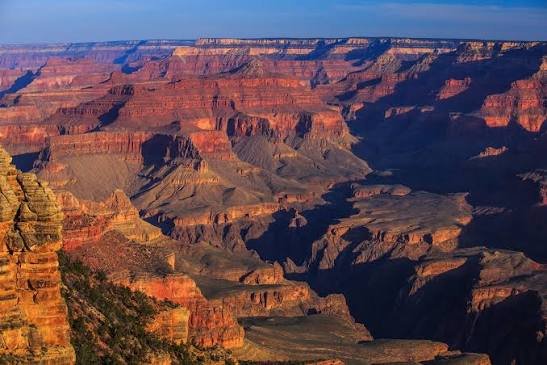
Rocks at the bottom of the Grand Canyon are nearly two billion years old, roughly half the age of the Earth itself, exposed layer by layer as the Colorado River carved through the Colorado Plateau over the past six million years. It’s a strange kind of time travel, standing at the rim and looking down through nearly two billion years of geologic history stacked in visible bands of rock. Few places on the planet let you see that much time at once.
Here’s what to know before visiting: where the park sits, what it costs, the numbers behind its almost incomprehensible scale, and the four-decade political fight it took just to get the canyon protected in the first place.
Grand Canyon National Park Overview
| Category | Details |
| Location | Northwestern Arizona |
| Main sections | South Rim (open year-round) and North Rim (seasonal) |
| Nearest city | Flagstaff, AZ (South Rim); closest to Kanab, UT (North Rim) |
| Nearest airport | Phoenix Sky Harbor International (PHX) |
| Established | February 26, 1919 — designated a national monument in 1908 |
| Total area | About 1.2 million acres (roughly 1,904 square miles) |
| Vehicle entrance fee | $35, valid 7 consecutive days (covers both rims) |
| Motorcycle fee | $30 |
| Per-person fee (foot/bicycle) | $20 |
| America the Beautiful Annual Pass | $80 (all U.S. national parks) |
| International visitor surcharge (2026) | $100 per person, age 16+ (waived with a qualifying annual pass) |
| Canyon length | About 277 river miles |
| Average depth | About 1 mile |
| Widest point | Up to 18 miles rim to rim |
| UNESCO status | World Heritage Site since 1979 |
| Annual visitation | Around 4.5 to 5 million visitors |
Where Grand Canyon National Park Is Located
Grand Canyon sits in northwestern Arizona, carved by the Colorado River as it winds roughly 277 miles through the Colorado Plateau. The park has two distinct visitor areas that function almost like separate destinations: the South Rim, open year-round and by far the more accessible and heavily visited side, and the North Rim, which sits at a higher elevation and typically closes for the season from mid-October through mid-May due to snow.
Flagstaff serves as the most common gateway city for South Rim visitors, roughly an hour and a half drive away, with Phoenix Sky Harbor International Airport offering the widest range of flight options for those flying in. Reaching the North Rim requires significantly more driving, since the two rims aren’t directly connected by any road through the canyon itself; getting from one side to the other by car means a roughly 215-mile drive around via a bridge near Lees Ferry.
One important distinction worth clearing up: Grand Canyon West, home to the glass Skywalk, is not part of Grand Canyon National Park at all. It operates on Hualapai tribal land under separate management, with its own entrance fees and rules entirely outside National Park Service jurisdiction.
What It Costs to Visit
A standard vehicle pass costs $35, covering everyone inside for seven consecutive days, and importantly, that single pass grants access to both the South Rim and North Rim during its validity window. Motorcycles pay $30, and visitors on foot or bicycle pay $20 per person.
Travelers planning trips to multiple national parks throughout the year typically prefer the $80 America the Beautiful Pass, which covers admission to every federal recreation site nationwide.
As of January 1, 2026, Grand Canyon joined ten other high-traffic parks in charging non-U.S. residents an additional $100 surcharge per person, on top of the standard entrance fee. A $250 non-resident annual pass waives that surcharge and typically saves money for families or groups planning to visit more than one qualifying park. It’s worth noting this surcharge applies only within the National Park Service boundary; it has no bearing on Grand Canyon West, which is governed entirely by the Hualapai Tribe.
Entrance stations here are fully cashless, so visitors need a credit or debit card, or can purchase a pass online in advance to reduce wait times, especially useful at the South Entrance during peak season.
Facts That Capture the Grand Canyon’s Scale
The canyon stretches roughly 277 river miles from the mouth of the Paria River near the Utah border to the Grand Wash Cliffs near Nevada, averaging about a mile deep from rim to river. At its widest point, the canyon spans up to 18 miles across, while its narrowest stretch, at Marble Canyon, squeezes down to just 600 feet.
Elevation varies significantly between the two rims: the South Rim sits at roughly 7,000 feet, while the North Rim rises higher still to about 8,000 feet, a difference that explains why the North Rim gets buried in snow and closes for months each year while the South Rim remains accessible year-round.
Biologically, the canyon spans five of North America’s seven life zones within a single park, the ecological equivalent of traveling from the deserts of Mexico to the boreal forests of Canada, all contained within one vertical mile of elevation change. That range supports remarkable diversity, including hundreds of bird species, dozens of mammal species, and plant life found nowhere else on Earth.
The History Behind Grand Canyon National Park
Protection efforts here took far longer than most people expect. The first bill proposing a Grand Canyon National Park was introduced in Congress in 1882 by Senator Benjamin Harrison, and it failed, along with follow-up attempts in 1883 and 1886. Once Harrison became president, he took a smaller step instead, establishing the Grand Canyon Forest Reserve in 1893.
Real momentum arrived with Theodore Roosevelt, who, after visiting the canyon and famously urging Americans to “leave it as it is,” used his presidential authority to designate Grand Canyon National Monument in 1908, protecting the area under the Antiquities Act rather than waiting for Congress to act. It still took another 11 years before Congress finally passed legislation establishing full national park status, which President Woodrow Wilson signed into law on February 26, 1919.
Long before any of that federal history, the canyon had been continuously inhabited for at least 2,000 years by Native peoples still connected to the region today, including the Hopi, Navajo, Zuni, Paiute, Havasupai, and Hualapai tribes. The park’s boundaries expanded significantly in 1975, when the Grand Canyon National Park Enlargement Act folded in the former Grand Canyon and Marble Canyon national monuments along with portions of Glen Canyon National Recreation Area, giving the park roughly its current footprint. UNESCO designated the site a World Heritage Site in 1979, recognizing both its geological significance and its unmatched scale.
Frequently Asked Questions
Q1. Does one entrance fee really cover both the South Rim and North Rim?
Yes. A single seven-day pass grants access to both rims, though given the roughly 215-mile drive between them, most visitors realistically pick one rim per trip rather than visiting both back-to-back.
Q2. Is Grand Canyon West with the Skywalk the same as Grand Canyon National Park?
No, and this causes real confusion. Grand Canyon West operates on Hualapai tribal land with its own separate entrance fees and management, completely outside National Park Service jurisdiction and the fee structure described here.
Q3. When is the North Rim actually open, and is it worth the extra drive?
The North Rim typically operates from mid-May through mid-October, closing for the rest of the year due to snow. It sees far fewer visitors than the South Rim and offers a quieter, arguably more scenic experience for those willing to make the longer trip.
Q4. Do I need a permit to hike below the rim, like to Phantom Ranch?
Day hikes below the rim don’t require a permit, but overnight backcountry camping does, and demand for popular routes like Bright Angel or South Kaibab often exceeds availability. Apply well in advance through the park’s backcountry permit system if an overnight rim-to-river hike is part of your plan.