Sledding down a sand dune 750 feet tall might sound like a novelty activity dreamed up for tourists, but at Great Sand Dunes, it’s genuinely the main event. These are the tallest dunes in North America, rising out of a Colorado valley floor against a backdrop of 13,000-foot peaks, a pairing so visually strange that it’s easy to forget you’re still in the Rocky Mountain state rather than somewhere along a coastline half a world away.
Here’s the practical guide for planning a visit: where the park sits, what it costs, the numbers behind its unusual geography, and the century-long path from mining threat to national monument to full national park status.
Great Sand Dunes National Park Overview
| Category | Details |
| Location | San Luis Valley, southern Colorado |
| Counties | Alamosa and Saguache |
| Nearest city | Alamosa, CO |
| Nearest airport | San Luis Valley Regional (ALS), or Colorado Springs/Denver for wider flight options |
| Established | March 17, 1932 (national monument); September 13, 2004 (national park and preserve) |
| Total area | About 149,000 acres combined park and preserve |
| Vehicle entrance fee | $25, valid 7 consecutive days |
| Motorcycle fee | $20 |
| Annual Pass | $45 |
| America the Beautiful Annual Pass | $80 (all U.S. national parks) |
| Payment method | Cashless — credit/debit card only |
| Tallest dunes | Star Dune and Hidden Dune, roughly 740–750 feet from base to summit |
| Dune field size | About 30 square miles |
| Highest peak (preserve) | Tijeras Peak, 13,604 feet |
| Annual visitation | Roughly 430,000 to 600,000 visitors |
Where Great Sand Dunes National Park Is Located
Great Sand Dunes sits in the San Luis Valley of south-central Colorado, wedged between the San Juan Mountains and the Sangre de Cristo Range. The nearest town of any size, Alamosa, sits about 35 miles from the park entrance, and while a small regional airport serves the immediate area, most visitors fly into Denver or Colorado Springs and drive the remaining three to four hours south.
There’s only one main road leading into the park, taking visitors past the visitor center to the main dunes parking area roughly a mile further on. Because the park is relatively compact and centered around a single access point, most first-time visitors spend their time at these two core stops rather than navigating a sprawling road network.
One detail that surprises many first-time visitors: the park is genuinely one of the quietest in the entire National Park System, a byproduct of its arid climate, isolated topography, and distance from major flight paths, making it a standout destination for both stargazing and simply experiencing natural silence.
What It Costs to Visit
A standard vehicle pass costs $25, valid for seven consecutive days, while motorcycles pay $20. Frequent visitors can pick up the $45 annual park pass, and anyone planning trips to multiple national parks during the year typically prefers the $80 America the Beautiful Pass, covering admission to every federal recreation site nationwide.
The park is open 24 hours a day, year-round, including for nighttime dark-sky viewing, and entrance stations are fully cashless, requiring a credit or debit card. Because the toll booth is only staffed between roughly 6 a.m. and 5 p.m., visitors arriving outside those hours can technically enter without immediately paying, though the fee remains owed and can be settled at the visitor center or paid online.
Given the park’s growing popularity, staff have flagged that visitation has climbed sharply in recent years, from a historical range of roughly 250,000 to 300,000 annual visitors up to around 600,000 during peak years in the 2020s, a jump that’s put real strain on parking and infrastructure during busy summer weekends.
Facts That Make Great Sand Dunes Unique
The dune field here covers roughly 30 square miles and holds the tallest dunes in North America, with Star Dune and Hidden Dune both reaching approximately 740 to 750 feet from base to summit. Reaching Star Dune typically involves about a two-mile hike south along the Medano Creek bed before climbing a ridge to the top, an effort best attempted early or late in the day during summer to avoid scorching sand temperatures.
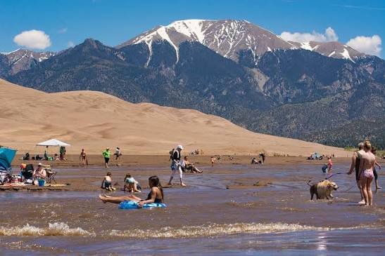
The dunes themselves formed from sand and gravel deposits carried down from the San Juan Mountains by ancient streams, later picked up by prevailing winds and blown eastward until they piled against the base of the Sangre de Cristo Range, where the mountains essentially trap the sand in place. Medano Creek, a seasonal waterway at the dunes’ edge, flows unpredictably each spring, creating small surge waves that make it a popular splash zone for visiting families during peak snowmelt.
Beyond the dunes, the park and preserve protect a genuinely varied set of ecosystems, including alpine lakes, tundra, spruce and fir forests, and grasslands, meaning a single visit can move from desert-like dune climbing to subalpine terrain within a relatively short distance.
The History Behind Great Sand Dunes National Park
People have lived in the San Luis Valley for roughly 11,000 years, and the dunes carry deep cultural and spiritual significance for tribes including the Ute and Navajo. The first recorded American exploration of the area came in January 1807, when Lieutenant Zebulon Pike crossed the Sangre de Cristo Mountains while surveying the newly acquired Louisiana Purchase territory under orders from President Thomas Jefferson.
By the 1920s, nearby residents grew concerned that gold mining or sand mining for concrete production might permanently damage the dunes, and local advocacy groups, including the P.E.O. Sisterhood, pushed for federal protection. Their efforts succeeded on March 17, 1932, when President Herbert Hoover signed the proclamation establishing Great Sand Dunes National Monument, initially covering roughly 35,500 acres.
Visitation grew steadily over the following decades, from just 500 visitors in the monument’s first year to nearly 93,000 by 1962, prompting infrastructure improvements including a new visitor center in 1961 and the Pinyon Flats Campground in 1964. The push for full national park status culminated in 2000, when President Bill Clinton signed legislation expanding the monument’s boundaries by nearly 70,000 acres and authorizing a new national preserve within the adjacent Rio Grande National Forest. That expansion also required purchasing the Baca Ranch to protect the valley’s critical water resources, a process that took an additional four years to complete. On September 13, 2004, Interior Secretary Gale Norton formally designated Great Sand Dunes National Park and Preserve, combining the original monument and new preserve into roughly 149,500 acres.
Frequently Asked Questions
Q1. Do I need special equipment to sled or sandboard on the dunes?
Yes, standard snow sleds and snowboards don’t work well on sand. Specialized sandboards and sand sleds, available for rent at shops just outside the park entrance, are strongly recommended for a functional experience.
Q2. When does Medano Creek actually have water for splashing and wading?
Peak flow typically occurs in late May through early June, driven by mountain snowmelt, and the creek often dries up completely by mid-to-late summer. Check current creek conditions before planning a visit specifically around it.
Q3. Is the hike to the tallest dunes difficult, and how long does it take?
Reaching Star Dune involves roughly a two-mile approach along the creek bed followed by a steep, physically demanding climb through soft sand. Plan for several hours round-trip, and avoid midday in summer when sand surface temperatures can become dangerously hot.
Q4. Why does this park feel so much quieter than other popular Colorado parks?
Its remote location in the San Luis Valley, away from major flight paths and interstate corridors, combined with an arid climate that limits sound carry, makes it one of the quietest national parks in the country, a quality the park actively promotes for stargazing and nighttime visits.