In May 1915, Lassen Peak blew a mushroom-shaped cloud of ash more than 30,000 feet into the sky, the most powerful volcanic eruption in the contiguous United States until Mount St. Helens erupted 65 years later. That single event is the reason this park exists at all, and the landscape it left behind still steams, bubbles, and boils today. Lassen Volcanic remains one of the only places on Earth where all four types of volcanoes, shield, plug dome, cinder cone, and composite, sit within a single park boundary.
Here’s the practical guide for anyone planning a visit: where the park sits, what it costs, the numbers behind its unusual volcanic variety, and the eruption that turned a quiet corner of Northern California into the nation’s 17th national park.
Lassen Volcanic National Park Overview
| Category | Details |
| Location | Northeastern California, southern Cascade Range |
| Counties | Shasta, Lassen, Plumas, and Tehama |
| Nearest cities | Redding and Susanville, CA |
| Nearest airport | Redding Municipal Airport (RDD) |
| Established | National monuments in 1907; national park August 9, 1916 |
| Total area | About 106,450 acres |
| Vehicle entrance fee | $30, valid 7 consecutive days |
| Individual fee (foot/bicycle/horse) | $12 |
| Motorcycle fee | $20 |
| Winter vehicle fee (Dec 1–Apr 15) | $10 |
| Lassen Annual Pass | $55 (also honored at Crater Lake, Lava Beds, and Whiskeytown) |
| America the Beautiful Annual Pass | $80 (all U.S. national parks) |
| Payment method | Cashless — credit/debit card only |
| Highest point | Lassen Peak, 10,457 feet |
| Main Park Road highest elevation | 8,512 feet — highest road in the Cascade Range |
| Annual visitation | Around 360,000 to 500,000 visitors |
Where Lassen Volcanic National Park Is Located
Lassen Volcanic sits in northeastern California along the southern end of the Cascade Range, spread across Shasta, Lassen, Plumas, and Tehama counties. Redding, the nearest city of size, sits roughly 48 miles from the north entrance via Highway 44, while Susanville offers another approach point from the southeast.
Redding Municipal Airport provides the most convenient air access, though many visitors drive up from the Bay Area or Sacramento as part of a broader Northern California itinerary. The park has entrances on both the northwest and southwest sides, connected by the 29-mile Main Park Road, which climbs to 8,512 feet near Lassen Peak, making it the highest road anywhere in the Cascade Range.
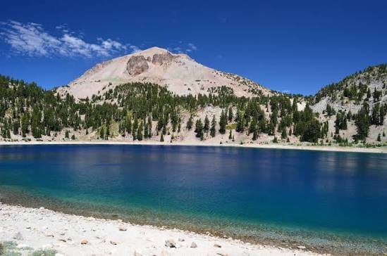
Snowfall shapes the park’s accessibility significantly. The Main Park Road typically doesn’t fully open until sometime between early May and mid-July depending on that year’s snowpack, and areas near Lake Helen can accumulate 40 feet of snow, with patches occasionally lingering into July.
What It Costs to Visit
A standard vehicle pass costs $30, valid for seven consecutive days. Individuals arriving on foot, bicycle, or horseback pay $12, and motorcycles pay $20. During winter months, from December 1 through April 15, a reduced $10 vehicle fee applies, reflecting the limited road access and facilities available that time of year.
Frequent visitors can pick up the $55 Lassen Annual Pass, which, thanks to a cooperative agreement among four nearby parks, is also honored at Crater Lake National Park, Lava Beds National Monument, and Whiskeytown National Recreation Area, a genuinely useful detail for anyone road-tripping through Northern California and southern Oregon. Travelers planning a broader national park itinerary typically prefer the $80 America the Beautiful Pass instead.
Entrance stations here are fully cashless, so a credit or debit card is required, and purchasing a pass online in advance through Recreation.gov is recommended, especially for remote entry points with self-registration “iron ranger” stations.
Facts That Make Lassen Volcanic Unique
Lassen Volcanic National Park is one of the only places in the world where visitors can see all four recognized types of volcanoes within a single protected area: Lassen Peak itself, the largest plug dome volcano on Earth; Prospect Peak, a shield volcano; Cinder Cone, a classic cinder cone formation roughly 350 years old; and Brokeoff Volcano, the eroded remnant of a much larger ancient composite stratovolcano.
The park’s hydrothermal features remain genuinely active today, including boiling mud pots, steaming fumaroles, and sulfurous gas vents, most famously at Bumpass Hell, named after Kendall Vanhook Bumpass, an early settler who severely burned his leg after breaking through the thin crust covering a boiling pool while exploring the area in the 1860s.
Lassen Peak’s 1914 to 1917 eruptive period represented the most recent volcanic eruption in the contiguous United States before Mount St. Helens erupted in 1980, and it remains part of an ongoing geological story: the park receives more precipitation than nearly anywhere else in the Cascade Range south of Oregon’s Three Sisters, and the region is considered among the most likely areas in the entire Cascade chain to shift from dormancy back into active eruption. More recently, the 2021 Dixie Fire burned over 73,000 acres within the park, more than 69% of its total area, making it the largest wildfire in the park’s recorded history.
The History Behind Lassen Volcanic National Park
President Theodore Roosevelt first protected this landscape in 1907, designating Cinder Cone and Lassen Peak as separate national monuments under the Antiquities Act, administered at the time by the U.S. Forest Service. That protection proved prescient: in May 1914, Lassen Peak reawakened after roughly 27,000 years of dormancy, beginning with a steam explosion that gradually enlarged into over 180 steam blasts.
The most dramatic moment came on May 22, 1915, when a major eruption sent a mushroom-shaped ash cloud more than 30,000 feet into the sky and triggered a devastating mudflow that destroyed several homes along nearby creeks, though advance warnings prevented any loss of life. National attention drawn by this eruption, along with continuing volcanic activity through 1917, provided the momentum needed for full federal protection. On August 9, 1916, President Woodrow Wilson signed legislation combining the two existing monuments and surrounding land into Lassen Volcanic National Park, the 17th national park established in the country.
The park’s Main Park Road was constructed between 1925 and 1931, just a decade after the eruptions that created the park in the first place, and extensive geologic monitoring began in the 1970s through collaboration with the U.S. Geological Survey, work that continues today given the region’s ongoing volcanic potential.
Frequently Asked Questions
Q1. When is the best time to see the volcanic hydrothermal features like Bumpass Hell?
Summer, typically July through September, offers the most reliable access, since heavy snowpack can keep sections of the Main Park Road and connecting trails closed well into early summer depending on the year’s snowfall.
Q2. Is it dangerous to walk near the boiling mud pots and fumaroles?
Yes, if you leave designated boardwalks and trails. The ground crust around thermal features can be thin and unstable, as Kendall Bumpass discovered firsthand in the 1860s, so staying on marked paths is essential safety practice, not just a park rule.
Q3. How did the 2021 Dixie Fire affect current visitor access to the park?
The fire burned a majority of the park’s total area, and some trails, facilities, and forested sections continue recovering in the years since. Check current park alerts before your trip, since specific closures or restoration areas can change from season to season.
Q4. Does the Lassen Annual Pass really work at other national parks too?
Yes. Through a cooperative agreement, the $55 annual pass purchased at Lassen is also honored at Crater Lake National Park, Lava Beds National Monument, and Whiskeytown National Recreation Area, making it a strong value if your trip covers more than one of these nearby sites.