Buried beneath West Texas lies the remains of a 400-mile ancient reef, built by marine organisms roughly 260 to 270 million years ago along the edge of a long-vanished Permian sea. Most of that reef still sits thousands of feet underground, invisible and unreachable. But at Guadalupe Mountains National Park, tectonic uplift pushed a section of it violently skyward, exposing one of the most complete and scientifically significant fossil reef formations anywhere on Earth, and in the process created the highest point in Texas.
Here’s the practical guide for anyone planning a visit: where the park sits, what it costs, the numbers behind its ancient marine geology, and the persistent efforts of an oil company geologist who fell in love with a canyon and gave the National Park Service the land needed to protect it.
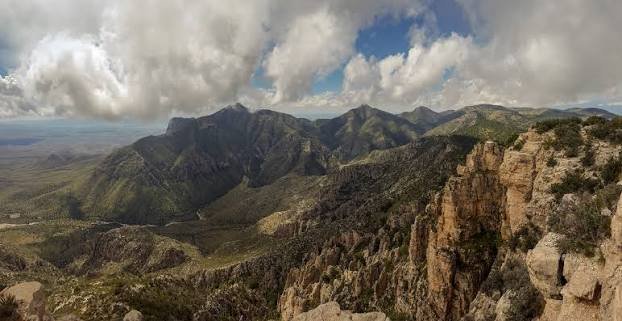
Guadalupe Mountains National Park Overview
| Category | Details |
| Location | Culberson and Hudspeth counties, West Texas, near the New Mexico border |
| Nearest city | El Paso, TX (about 2 hours away) |
| Nearest airport | El Paso International Airport (ELP) |
| Established | Authorized 1966; established September 30, 1972 |
| Total area | About 86,367 acres |
| Entrance fee | $10 per person, age 16 and older (not per vehicle) |
| America the Beautiful Annual Pass | $80, covers the fee for up to 4 people |
| Reservations | Not required — no timed entry, no advance booking needed |
| Highest point | Guadalupe Peak, 8,749–8,751 feet — tallest point in Texas |
| Lowest point | Salt Basin Dunes, around 3,640–3,650 feet |
| Wilderness designation | About 46,850 acres |
| Annual visitation | Around 200,000 to 245,000 visitors |
Where Guadalupe Mountains National Park Is Located
Guadalupe Mountains National Park sits in far West Texas, right along the New Mexico border, roughly a two-hour drive east of El Paso. El Paso International Airport is the closest major airport and the natural starting point for most visitors, since the park itself sits in a genuinely remote stretch of desert with limited nearby services.
Pine Springs functions as the main hub of the park, home to the primary visitor center, the Pine Springs Campground, and trailheads leading to Guadalupe Peak, Devil’s Hall, and El Capitan, the dramatic limestone cliff visible from miles away as you approach on the highway. Many visitors pair a trip here with nearby Carlsbad Caverns National Park just across the state line in New Mexico, combining a summit hike at Guadalupe’s highest point with a descent hundreds of feet underground at Carlsbad on the same trip.
What It Costs to Visit
Here’s a detail that catches many first-time visitors off guard: Guadalupe Mountains charges its entrance fee per person rather than per vehicle, at $10 for anyone 16 and older, with children 15 and under admitted free. That means a group of three adults traveling together should expect to pay $30 total, a different structure than the flat vehicle rate used at most other national parks.
The park has no fee collection booths at a gate. Instead, visitors are expected to stop at the visitor center to pay and display a receipt on their dashboard, or purchase online in advance before arriving. The $80 America the Beautiful Pass covers this fee entirely for up to four people traveling together, making it a strong value here given the per-person structure, and no advance reservation or timed entry is required to enter the park at any time of year.
Facts That Make Guadalupe Mountains Geologically Significant
The Guadalupe Mountains represent one of the best-preserved and most extensive exposed sections of a Permian-era fossil reef found anywhere in the world, formed along a shelf in an ancient sea roughly 250 to 270 million years ago. Mountain-building activity between 10 and 12 million years ago thrust this section of the ancient reef upward, exposing it to weathering and erosion that revealed the limestone formations visible in the park today. On the western side, where the reef broke sharply during that uplift, limestone palisades rise nearly a mile above the surrounding salt flats below.
At 8,749 feet, Guadalupe Peak is the highest point in the entire state of Texas, reachable via a strenuous 4.2-mile trail gaining roughly 3,000 feet of elevation, typically requiring six to eight hours round trip. Elevation swings dramatically across the park, from that summit down to around 3,640 feet at the Salt Basin Dunes, creating distinct ecological zones within a relatively compact area.
Wildlife has seen genuine recovery here in recent decades: elk, absent from the Guadalupe Mountains for over a century, have naturally returned to the park from nearby reintroduction sites in the surrounding region, a quiet conservation success story unfolding alongside the park’s more famous geological attractions.
The History Behind Guadalupe Mountains National Park
Archaeological evidence shows humans have inhabited this rugged mountain range for at least 10,000 to 12,000 years, with hunter-gatherer peoples living among the range’s numerous caves and alcoves long before recorded history. The Mescalero Apache were the most recent Indigenous inhabitants before the U.S. Army forcibly displaced them during the 1860s and 1870s, clearing the way for settlers seeking the area’s limited water and shelter resources.
A short-lived stagecoach era briefly touched this landscape too: the ruins of a Butterfield Overland Mail station still stand at the base of El Capitan, marking a stage route that operated only from 1858 to 1859 before the Civil War disrupted mail service across the region. Ranching continued in the area through the following century, though the arid, unforgiving terrain proved difficult for most agricultural operations to sustain long-term.
The park’s creation owes much to geologist Wallace Pratt, who worked for the Humble Oil Company and grew captivated by McKittrick Canyon during early geological surveys of the region’s oil-bearing formations. Pratt donated his 5,632-acre ranch to the National Park Service in 1961, providing the essential nucleus of land around which the broader park was eventually built. Rancher J.C. Hunter also contributed significantly to the effort. Congress authorized the park in 1966, and after years of assembling the necessary land parcels and mineral rights, Guadalupe Mountains National Park was officially established on September 30, 1972.
Frequently Asked Questions
Q1. Does the entrance fee really apply per person, or is that a mistake?
It’s genuinely per person, not per vehicle, one of the few national parks structured this way. A family or group should calculate their total cost by multiplying the $10 fee by each person 16 or older in their party, unless they’re covered by an America the Beautiful Pass.
Q2. Do I need to make a reservation to visit or hike Guadalupe Peak?
No. Unlike parks such as Yosemite or Rocky Mountain, Guadalupe Mountains requires no advance reservation or timed entry permit for general park access or day hiking, including the popular Guadalupe Peak Trail.
Q3. Is it worth combining a trip here with Carlsbad Caverns National Park?
Yes, many visitors do exactly that, since the two parks sit relatively close together across the Texas-New Mexico border. Pairing a Guadalupe Peak summit hike with an underground Carlsbad Caverns tour makes for a genuinely striking elevation contrast within a single trip.
Q4. What’s the best time of year to see fall colors in McKittrick Canyon?
Late October through mid-November typically offers the best fall foliage display in McKittrick Canyon, though exact timing shifts year to year based on rainfall and temperature patterns, so checking recent park updates before a color-focused trip is worthwhile.