About 7,700 years ago, a volcano nearly a mile taller than the mountain that stands there today erupted with a force roughly 42 times more powerful than Mount St. Helens in 1980. The top of Mount Mazama collapsed inward, leaving behind a massive caldera that slowly filled with centuries of rain and snowmelt. No rivers flow in. No rivers flow out. What remains is Crater Lake, the deepest lake in the United States, so clear and undisturbed that its water takes on a blue so saturated it looks almost artificial.
Here’s the practical guide for planning a visit: where the park sits, what it costs, the numbers behind its extraordinary depth, and the decades one determined explorer spent turning a volcanic scar into Oregon’s only national park.
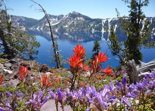
Crater Lake National Park Overview
| Category | Details |
| Location | Southern Oregon, Cascade Range |
| Nearest city | Medford, OR (about 50 miles away) |
| Nearest airport | Rogue Valley International–Medford Airport (MFR) |
| Established | May 22, 1902 — America’s fifth national park |
| Total area | About 183,000 acres (roughly 286 square miles) |
| Peak season fee (May 22–Oct 31) | $30 vehicle / $25 motorcycle / $15 per person |
| Off-season fee (Nov 1–May 21) | $20 vehicle / $15 motorcycle or individual |
| Crater Lake Annual Pass | $55 (also honored at Lava Beds National Monument) |
| America the Beautiful Annual Pass | $80 (all U.S. national parks) |
| Payment method | Cashless at entrance stations |
| Lake depth | 1,949 feet — deepest lake in the U.S. |
| Caldera formed | About 7,700 years ago, from Mount Mazama’s collapse |
| Rim Drive length | Roughly 33 miles around the caldera |
| Annual visitation | Around 500,000 to 700,000 visitors |
Where Crater Lake National Park Is Located
Crater Lake sits in the Cascade Range of southern Oregon, roughly 50 miles northeast of Medford and about a five-hour drive south from Portland. Rogue Valley International–Medford Airport is the most convenient arrival point for most visitors, offering a manageable drive up into the mountains to reach the park entrance.
The park is genuinely remote by Pacific Northwest standards, sitting at elevations between 6,000 and 8,000 feet along the caldera rim, which shapes almost everything about visiting. Rim Drive, the roughly 33-mile road circling the lake, offers dramatic overlooks at nearly every turn, but access to it depends heavily on the season.
Winters here are severe. The North Entrance Road and much of Rim Drive typically close by late October or early November and don’t reopen until late spring or early summer, since the area receives an average of more than 40 feet of snow annually. During winter closures, visitors access the park exclusively through Highway 62 on the south side, where the Rim Village area and a shorter stretch of road stay open and plowed year-round.
What It Costs to Visit
Crater Lake uses a seasonal fee structure, unlike most national parks with a single year-round rate. During peak season, from May 22 through October 31, a vehicle pass costs $30, motorcycles pay $25, and pedestrians or cyclists pay $15 per person. During the off-season, from November 1 through May 21, the vehicle fee drops to $20, while motorcycles and individuals both pay $15.
Frequent visitors can pick up the $55 Crater Lake Annual Pass, which is also honored at nearby Lava Beds National Monument, a useful detail for anyone combining both stops on a Pacific Northwest road trip. Travelers planning visits to multiple national parks during the year typically prefer the $80 America the Beautiful Pass instead, covering admission to every federal recreation site nationwide.
Entrance stations here are cashless, so visitors need a credit or debit card, or can purchase a pass online in advance through Recreation.gov before arriving, which also tends to shorten wait times at the gate itself.
Facts That Make Crater Lake Extraordinary
At 1,949 feet deep, Crater Lake holds the title of deepest lake in the United States and ranks among the ten deepest lakes on Earth. What makes that depth especially remarkable is the lake’s water source: it has no inlets or outlets whatsoever. Every drop comes directly from rain and snowmelt, and water is lost only through evaporation and slow subsurface seepage, a closed system that keeps the lake exceptionally clear and contributes to its famously saturated blue color.
The caldera itself measures roughly 6 by 9 kilometers across, formed when the volcano’s summit collapsed following the massive eruption around 7,700 years ago. Within the caldera sits Wizard Island, a cinder cone that rose from later, smaller volcanic activity after the main collapse, now standing about 764 feet above the lake’s surface and forming one of the park’s most photographed features.
Indigenous peoples, including the Klamath and Modoc, the Yahooskin Band of Northern Paiute, and the Cow Creek Band of Umpqua, maintain deep ancestral ties to this landscape, with oral traditions describing the catastrophic eruption that created the lake, passed down across roughly 7,600 years of continuous connection to the site.
The History Behind Crater Lake National Park
Long before it became a national park, the volcano and its collapse were witnessed directly by the ancestors of tribes still connected to the region today, whose stories about the eruption persist in oral tradition despite lacking written records of the event itself.
Modern exploration and advocacy trace back significantly to William Gladstone Steel, who spent decades campaigning for the lake’s federal protection after first learning of its existence as a young man. In 1886, Steel worked alongside geologist Clarence Dutton on a U.S. Geological Survey expedition, hauling a half-ton survey boat up the caldera’s steep slopes to measure the lake’s depth using a piece of pipe lowered on piano wire at 168 different spots. Their deepest measurement, 1,996 feet, came remarkably close to the modern sonar-verified depth of 1,949 feet.
Steel’s persistence eventually paid off. On May 22, 1902, President Theodore Roosevelt signed the legislation establishing Crater Lake National Park, making it the fifth national park in the country and the only one located in Oregon. Development continued in the following decades: the park’s first lodge opened in 1915, and Rim Drive, giving the public full vehicular access around the lake, was completed in 1918, shaping much of how visitors still experience the park today.
Frequently Asked Questions
Q1. Is the entire Rim Drive open year-round?
No. Heavy snowfall closes most of Rim Drive and the North Entrance Road from roughly late October through late spring or early summer. During that period, access is limited to Highway 62 and the Rim Village area on the south side, which stay open and plowed year-round.
Q2. Can I swim in Crater Lake, and if so, how do I get down to the water?
Yes, swimming is allowed at Cleetwood Cove, the only trail providing direct lake access. It’s a steep 1.1-mile trail down (and a demanding climb back up), and it’s the sole legal access point to the water’s edge.
Q3. Why does the lake look different colors depending on when I visit?
The lake’s blue intensity shifts with sunlight angle, weather, and time of day, appearing deepest blue on clear, sunny days near midday. Overcast conditions or early morning light can make the water appear more muted or gray.
Q4. Is a boat tour worth adding to my visit, and does it require a reservation?
Boat tours to Wizard Island are popular and often sell out during peak summer months, so booking in advance is strongly recommended. They also require hiking down and back up the Cleetwood Cove Trail to reach the boat dock, so factor that into your timing.