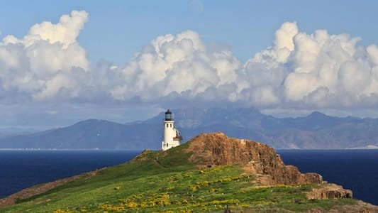
There’s no gate to drive through at Channel Islands National Park. There’s no road at all, actually. Reaching this park means a ferry ride of two and a half hours or more across open Pacific water, and once you arrive, you’ll find no restaurants, no gas stations, and often no cell service, just windswept islands home to a fox smaller than a housecat found absolutely nowhere else on Earth. Locals sometimes call it “California’s Galápagos,” a nickname the islands’ isolated evolutionary history genuinely earns.
Here’s the practical guide for anyone planning a visit: where the park sits, what it costs (free to enter, though the boat definitely isn’t), the numbers behind its unusual isolation, and the decades it took to protect all five islands under one national park designation.
Channel Islands National Park Overview
| Category | Details |
| Location | Pacific Ocean, off the coast of Santa Barbara County and Ventura County, California |
| Islands protected | Anacapa, Santa Cruz, Santa Rosa, San Miguel, and Santa Barbara |
| Nearest cities | Ventura and Oxnard, CA (main ferry departure points) |
| Nearest airport | Los Angeles International (LAX), about 1.5–2 hours from Ventura |
| Established | National monument in 1938; national park on March 5, 1980 |
| Total area | About 249,561 acres (roughly half land, half ocean) |
| Entrance fee | None — free to enter the park |
| Ferry cost | Separate fee, not covered by any national park pass |
| Highest point | El Montañon (Mount Montañon), Santa Cruz Island, 1,812 feet |
| Endemic species | Over 150 found nowhere else on Earth, including the island fox |
| Annual visitation | Around 300,000 to 325,000 visitors |
Where Channel Islands National Park Is Located
Channel Islands National Park sits off the coast of Southern California, protecting five of the eight Channel Islands, spread across a roughly 160-mile stretch of the Pacific Ocean within Santa Barbara and Ventura counties. Unlike virtually every other national park, there’s no way to drive here; the mainland visitor center in Ventura serves as the primary point of departure, with most ferry trips launching from either Ventura Harbor or Oxnard.
Los Angeles International Airport is the most practical arrival point for most visitors, followed by a drive of roughly an hour and a half to two hours to reach Ventura. From there, ferry crossings to the islands typically take two and a half hours or more, depending on the destination island and sea conditions, and travelers should expect genuinely rough water on occasion given the exposed Pacific crossing.
Santa Cruz Island, the largest in the park at roughly 60,000 acres, is jointly managed between the National Park Service, which owns about 24%, and the Nature Conservancy, which owns the remaining 76%, an unusual dual-ownership arrangement that shapes access and management across the island.
What It Costs to Visit
Channel Islands National Park charges no entrance fee at all. You can visit the mainland visitor center in Ventura, and if you make it out to any of the islands themselves, walking their trails and beaches costs nothing.
What isn’t free, and what most visitors actually spend money on, is getting there. Ferry tickets and any flights to the islands are entirely separate costs, booked through concessionaires rather than the National Park Service itself, and importantly, no national park pass, including the America the Beautiful Pass, covers ferry or transportation fees. Ferries typically depart in the morning, giving visitors a full day on the island before returning in the afternoon or evening.
Camping is available on several islands but requires advance reservations and, like everything else here, its own separate fee on top of the ferry cost to actually reach the campsite.
Facts That Make Channel Islands Unique
The park protects more than 150 species found nowhere else on Earth, a level of endemism that earns comparisons to the Galápagos Islands. The most famous of these is the island fox, roughly the size of a well-fed housecat and the largest native land mammal across the islands, having evolved independently on each individual island within the park to the point where subspecies now differ meaningfully from one island to the next.
Human history here runs remarkably deep. Archaeologists have documented evidence of seafaring peoples on the islands dating back more than 13,000 years, with Santa Rosa and San Miguel holding the highest concentration of prehistoric sites anywhere in North America, some traced back 9,000 to 13,000 years. The islands supported the Chumash and Tongva peoples for thousands of years before European contact, sustained by the surrounding ocean’s resources.
Elevation across the park ranges from sea level up to 1,812 feet at El Montañon on Santa Cruz Island, and despite sitting so close to one of the most densely populated coastlines in the country, the islands’ relative isolation has kept them remarkably undeveloped compared to the mainland just a short ferry ride away.
The History Behind Channel Islands National Park
Following European contact in the 16th century, the islands cycled through various uses over the following centuries, including ranching operations and periods of military use that altered native ecosystems significantly. Federal protection began modestly: Santa Barbara and Anacapa Islands were designated Channel Islands National Monument in 1938, decades before the broader park existed.
Momentum for expanded protection built through the mid-20th century, and on March 5, 1980, President Jimmy Carter signed Public Law 96-199, establishing Channel Islands National Park and expanding federal protection to include Santa Rosa, Santa Cruz, and San Miguel Islands alongside the original two. At the time, Santa Rosa and Santa Cruz remained privately owned, and San Miguel remained U.S. Navy property, a status that continues today even though the National Park Service manages it.
Land acquisition continued gradually in the decades that followed. The National Park Service purchased Santa Rosa Island from private owners Vail and Vickers in 1986, and acquired roughly 10% of Santa Cruz Island during the 1990s. In 2000, the Nature Conservancy donated 8,500 acres of its Santa Cruz holdings to the National Park Service, though the Conservancy retained ownership of the majority of the island, an arrangement that persists as the current management structure today.
Frequently Asked Questions
Q1. Can I use my America the Beautiful Pass to cover the ferry cost?
No. National park passes only waive entrance fees, and since Channel Islands has no entrance fee to begin with, the pass has no bearing on ferry or boat transportation costs, which must be booked and paid for separately through the ferry concessionaire.
Q2. Which island should I visit if I only have time for one day trip?
Santa Cruz Island is the most popular choice for a single-day visit, offering a range of hiking options from easy coastal walks to more strenuous multi-mile trails, along with the best odds of spotting an island fox up close.
Q3. Is seasickness a real concern on the ferry crossing?
It can be, given the exposed open-water crossing and occasionally choppy conditions. If you’re prone to motion sickness, consider taking preventive medication before departure and expect rougher seas during winter months compared to late spring through early fall.
Q4. When is the best time to see migrating whales from the islands?
Winter months typically offer the best chance to spot migrating whales offshore, though sightings aren’t guaranteed on any given trip. Late spring through early fall generally offers calmer seas and more reliable weather for hiking and kayaking instead.