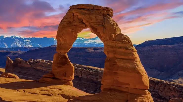
More than 2,000 natural stone arches sit within a single park boundary in eastern Utah — the densest concentration of these formations found anywhere on Earth. Some span the length of a football field. Others are barely large enough to walk through. All of them exist because of a strange combination of ancient salt beds, sandstone, and millions of years of patient erosion, and all of them sit within a park small enough to explore thoroughly in two or three days.
If you’re planning a trip near Moab, here’s the practical rundown: where Arches sits, what it costs to get in, the numbers that make it unique, and how a prospector’s letter to a railroad company eventually turned this red-rock landscape into a national park.
Arches National Park Overview
|
Category |
Details |
|
Location |
Eastern Utah, Grand County |
|
Nearest city |
Moab, UT (about 5 miles south) |
|
Nearest airport |
Canyonlands Regional Airport (CNY), Moab |
|
Established |
April 12, 1929 (as a national monument); November 12, 1971 (as a national park) |
|
Total area |
About 76,500 acres (roughly 119 square miles) |
|
Vehicle entrance fee |
$30, valid 7 consecutive days |
|
Motorcycle fee |
$25 |
|
Per-person fee (foot/bicycle) |
$15 |
|
Local Annual Pass |
$55 (also covers Canyonlands, Natural Bridges, Hovenweep) |
|
America the Beautiful Annual Pass |
$80 (all U.S. national parks) |
|
Timed entry reservation (2026) |
Not required — system was dropped for the 2026 season |
|
Documented arches |
Over 2,000 |
|
Longest arch |
Landscape Arch, 306 feet |
|
Highest point |
Elephant Butte, 5,653 feet |
|
Main park road length |
About 18 miles, entrance to Devils Garden |
|
Annual visitation |
Roughly 1.5 million visitors |
Where Arches National Park Is Located
Arches sits in eastern Utah, just five miles north of Moab along US-191, making it one of the more accessible parks in the Southwest despite its remote-feeling desert scenery. The Colorado River runs along part of the park’s southern boundary, and the entrance station sits close enough to town that many visitors stay in Moab and drive in for day trips rather than camping inside the park itself.
The closest airport, Canyonlands Regional, sits just north of Moab, though many travelers fly into Salt Lake City or Grand Junction, Colorado, and drive the remaining few hours instead, since flight options into the smaller regional airport are limited.
A single 18-mile paved road runs from the entrance station to the Devils Garden trailhead at the park’s far end, with spur roads branching off to major sights like the Windows section, Balanced Rock, and the trailhead for Delicate Arch. Because the park is compact, most first-time visitors can see its headline attractions in a single well-planned day, though serious hikers often stretch a visit to two or three.
Ticket Prices and Entrance Fees
A standard vehicle pass costs $30 and covers everyone inside for seven consecutive days. Motorcycles pay $25, and visitors arriving on foot or by bicycle pay $15 per person.
For anyone spending extended time in the Moab area, the $55 local annual pass is worth considering, since it also covers neighboring Canyonlands National Park along with Natural Bridges and Hovenweep National Monuments. Travelers planning a broader national park trip typically opt for the $80 America the Beautiful Pass instead, which works at every federal recreation site in the country.
One important update for 2026: unlike the timed entry systems still running at parks like Rocky Mountain and Zion, Arches dropped its reservation requirement entirely for this season, after running one in various forms since 2021. That means no advance booking, no $2 processing fee, and no need to log onto a reservation site months ahead of a trip. The tradeoff is that popular parking areas — especially at Delicate Arch, the Windows, and Devils Garden — still fill up quickly during peak hours, and rangers can temporarily close access to those specific lots when they do, sometimes for several hours at a stretch. Arriving before 8 a.m. or after 4 p.m. remains the most reliable way to avoid that bottleneck during the busy spring and fall seasons.
Arches also isn’t among the parks currently charging the $100 nonresident surcharge that applies at places like Zion, Yosemite, and Rocky Mountain, so entrance costs here stay the same regardless of a visitor’s country of residence.
Facts That Make Arches Unique
The park’s defining feature is its geology. More than 2,000 documented natural arches sit within its boundaries, more than anywhere else on the planet, ranging from openings just a few feet wide to Landscape Arch, which stretches 306 feet across and ranks among the longest natural rock spans in North America.
The formations owe their existence to an ancient underground salt bed, laid down more than 300 million years ago. As sandstone layers piled on top over millions of years, the buried salt shifted and buckled, cracking the rock above into long parallel fins. Wind, rain, and freeze-thaw cycles then went to work on those fins for millions of years, hollowing out the openings that eventually became arches.
Elevation across the park ranges from about 4,085 feet near the visitor center to 5,653 feet at Elephant Butte, and the region receives less than 10 inches of rain annually, making it one of the drier landscapes in the entire national park system. Despite that aridity, the park supports a surprising range of high-desert wildlife, from desert bighorn sheep to a variety of lizards and birds adapted to the extreme temperature swings between day and night.
The History Behind Arches National Park
Long before European settlement, ancient hunter-gatherer peoples moved through this landscape, followed by Ancestral Puebloan communities and later the Ute and Paiute peoples, whose presence in the region predates any recorded history. Spanish explorers passed nearby in the late 1700s along what’s now known as the Old Spanish Trail, still visible near the park’s visitor center today.
Federal protection began with an unlikely champion: a local prospector named Alexander Ringhoffer, who wrote to the Rio Grande Western Railroad in 1923 hoping to drum up interest in the area’s rock formations. He personally guided railroad executives on hikes through the terrain, and they, recognizing tourism potential for their rail line, helped push the idea toward Washington. On April 12, 1929, President Herbert Hoover signed the proclamation establishing Arches National Monument, initially covering a modest 4,520 acres split between the Windows area and Devils Garden.
A scientific expedition in 1933 and 1934, led by local newspaper editor Frank Beckwith, mapped and named many of the park’s most famous features, including Delicate Arch, Landscape Arch, and Tower Arch. The monument grew substantially in 1938 under President Franklin Roosevelt, expanding to nearly 34,000 acres. Development remained slow, though — the first paved road wasn’t completed until 1958, decades after the monument’s creation.
Full national park status finally arrived on November 12, 1971, when President Richard Nixon signed the legislation elevating Arches to the 35th national park in the system, setting its boundaries at roughly their present size.
Frequently Asked Questions
Do I need a permit to hike to Delicate Arch?
No permit is required for the main trail to Delicate Arch, which is a moderate 3-mile round trip. However, parking at the trailhead fills quickly, especially near sunset, so arriving well before your planned hike time matters more than any permit system.
Is the Fiery Furnace area open to casual hikers?
No. Fiery Furnace requires either a self-guided permit or a ranger-led tour, both booked in advance through Recreation.gov, due to the maze-like terrain and risk of getting lost without route-finding experience.
Since the timed entry system ended, will I still face long lines to get in?
Possibly. While the reservation requirement is gone for 2026, entrance lines can still stretch 30 minutes or more between 8 a.m. and 3 p.m. during peak season, since overall visitor volume hasn’t changed, only the booking system has.
What’s the best season to visit if I want cooler hiking temperatures?
Spring (March through May) and fall (September through November) offer the most comfortable hiking conditions. Summer temperatures regularly exceed 100°F on exposed sandstone trails, making early morning or evening hikes strongly preferable during that season.